


See all Mountains in Gangotri
Bhagirathi Peaks
Bhagirathi Peak,Uttarakhand, 249135 India Phone: Not availableAbout
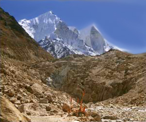
Bhagirathi PeakIn the Garhwal Himalayas lies the magnificent Bhagirathi group of three soaring peaks - Bhagirathi I, Bhagirathi II and Bhagirathi III, rising to the heights of 6,856 metres, 6,512 metres, and 6,454 metres respectively. The highest peak of the imposing Bhagirathi cluster forms an elaborate and topographically complex mastiff. It stands awe-inspiring and dominates the end of the valley leading up to Gaumukh, which marks the end of the Gangotri Glacier and the source of the holy River Ganga. Bhagirathi is also the name given to the upper part of the Ganga. Both the mountain and the river are said to be named after King Bhagirath, who supposedly coerced Goddess Ganga to descend from the heavens in the form of a raging torrent as an answer to his severe and unwavering austerities. The Bhagirathi Glacier in the upper Alaknanda basin, along with other glaciers like the Satopanth Glacier, is the source of the River Alaknanda. These glaciers are located at a distance of 17 kilometres from the renowned temple of Badrinath, in the district of Chamoli. They begin in the Chaukhamba and Badrinath cluster of peaks, which separate them from the Gangotri group of glaciers. Bhagirathi can be reached from Joshimath in the sub-division of Chamoli, by following the Badrinath and Mana motorable road. From the village of Mana, the route trails the path of the River Alaknanda. A 145-metre waterfall known as Vasundhara lies on the right bank of the Alaknanda and is perched at a height of 3,250 metres. Major mountain expeditions can be enjoyed in the months of May, June and September.",